Navionics
Navionics
Product Description
- NEW chart available: XL9 Australia & NZ for $369.99 inc GST
- Platinum chart available: $555.99 inc GST
Gold Card : AUSTRALIA & New Zealand : MSD-XL9 – 50XG
Boat safer and savor every moment on the water! All-in-one max detailed cartography for marine and lakes makes Navionics+ the perfect choice for cruising, sailing and fishing. Get the most accurate navigational data, an exclusive 0.5 m HD bathymetry map which is enhanced by boaters like you, and unique local content shared by Navionics app users. Daily updates and advanced features are included for one year.
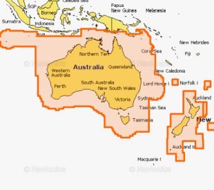
Above graphic is representative of coverage area, boundaries should not be considered precise.
Platinum Card
All the same marine content and advanced features found in Navionics+ are augmented with 3D View, satellite overlay and panoramic photos of marinas and harbors. Consult a broader set of resources, including port services and local points of interest, that can help you head into new waters with confidence.
| PLATINUM CODE |
TITLE | DESCRIPTION |
| 60P | AUSTRALIA N & W | Australia North, Australia West. From Esperance Bay to Halifax Bay. Including North Great Barrier Reef, Torres Strait, Gulf of Carpenteria, Malville Island, Joseph Bonaparte Gulf, Shark Bay, Perth. |
| 61P | AUSTRALIA SOUTH | Australia South, Tasmania. From Perth to Wollongong Harbour. Including Great Australian Bight, Spencer Gulf, Gulf ST, Vincent, Kangaroo Island, Bass Strait, Furneaux Group, King Island, Melbourne, Adelaide. |
| 62P | AUSTRALIA E & N | Australia East. From Cape York Peninsula to Bass Strait, Tasmania. Including Furneaux Group, Lord Howe Island, Great Barrier Reef, Coringa Islands, Brisbane, Sydney, Deboyne Islands, Milne Bay, Melbourne and Norfolk Islands. |


